Indices & Data
ETCCDI Climate Change Indices and Software
The joint CCl/CLIVAR/JCOMM Expert Team (ET) on Climate Change Detection and Indices (ETCCDI) has a mandate to address the need for the objective measurement and characterization of climate variability and change by providing international coordination and helping organizing collaboration on climate change detection and indices relevant to climate change detection, and by encouraging the comparison of modeled data and observations. Issues being addressed include the practical aspects of developing guidance and materials for NMHSs - toolkits including software, documentation, and other material to guide the calculation and use of climate change detection indices and climate data homogenization, improvement of global coverage and assessment of indices. The ET is also concerned with improving indices and analysis tools.
The main purpose of the ETCCDI indices and software website is to provide:
- ET approved definitions and guidance on the calculations of climate change indices, along with standard software packages
- Practical guidance on the homogenization of climate data
- Materials for use in ETCCDI training workshops
- Access to online resources of climate indices
- A place for the submission of new or updated indices data
The software packages for data homogeneization (RHtestsV3) and indices calculation (RClimDex) are based on a very powerful and freely available statistical package R which runs under both MicroSoft Windows and Unix/Linux.
ClimDex
The CLIMDEX project aims to produce a suite of in situ and gridded land-based global datasets of indices representing the more extreme aspects of climate. Indices are derived from daily temperature and precipitation data using the definitions recommended by ETCCDI. The project also aims to develop software tools to allow users to access the resulting datasets via a Web interface.
The main purpose of this website is to:
• Provide easy access to climate extremes data for research purposes
• Assess spatial and temporal variability of climatic extremes
• Assess uncertainties in the representation in extremes
• Evaluate climate model output (with knowledge of the uncertainties in the observational datasets)
• Provide traceability for data and methods used
This site provides access to datasets, including detailed information on their construction, (revision-controlled) software, trend maps, time series, and uncertainty estimates. The web portal will also provide similar access to the indices calculated from CMIP3 and CMIP5 model data.
European Climate Assessment & Dataset (ECA&D)
The ECA&D is the European contribution to the worldwide set of ETCCDI indices.
The objective of ECA&D is to combine collation of daily series of observations at meteorological stations, quality control, analysis of extremes and dissemination of both the daily data and the analysis results. It is a joint activity of about 40 National Meteorological and Hydrological Services and 10 Universities in Europe and the network of participants is graduately extended to countries in the Middle East and countries in North Africa.
The goal is to describe the past evolution of climate extremes (land-atmosphere) and is based on a centralised data archive of station records.
The ECA&D dataset consists of daily station series obtained from climatological divisions of National Meteorological and Hydrological Services and station series maintained by observatories and research centres throughout Europe and the Mediterranean. A comprehensive overview of all available data is provided in the data dictionary and new versions of the daily dataset will be issued at regular intervals.
The interactive web interface (http://eca.knmi.nl) provides:
- daily data records for temp, precip, humidity, cloud cover, snow depth, slp, sunshine, plus metadata (roughly 60% of ~3300 stations from ~60 countries downloadable) - indices for moderate extremes (27 ETCCDI indices plus many more for snow, drought, etc.) - return values for more rare extremes (based on GEV analysis for consecutive 20yr periods) - factsheets for significant weather events from the past (GEO themes energy, health, disasters, water, etc.) - complete documentation on data processing steps
The web interface provides time series plots, trend maps, climatology/anomaly maps, and return value maps for selected stations, time periods, etc.
Data is also available from KNMI's Climate Explorer.
The website, database and processing software is openly available for use in other regions of the world and the system is now being implemented for the region Indonesia, Malaysia, Thailand, Philippines. The E-OBS (see below) gridding technique has also been used in Mexico and South America.
The new EU-funded project EURO4M (2010-2014) will synthesize the station based results of ECA&D with satellite climate data records of CM-SAF (EUMETSAT) to produce new regional reanalyses by UKMO, SMHI, MF.
South East Asian Assessment & Dataset (SACA&D)
SACA&D is developed as part of the Digitisasi Data Historis (Didah) project. This project is focusing on the digitization and use of high-resolution historical climate data from Indonesia and other Southeast Asian countries. Didah is a joint project between the National Meteorological Services of Indonesia (BMKG) and the Netherlands (KNMI). The results on this website contribute to the work of the Asian Pacific Network for climate extremes (APN).
KNMI Climate Explorer
A research tool that allows anyone to correlate station data, climate indices, observations, reanalysis fields, past seasonal forecasts and climate change experiments. The Climate Explorer web site provides access to different climate data and analysis tools to to investigate it, correlate it to other data, and generate derived data from it.
Gridded Datasets
|
|
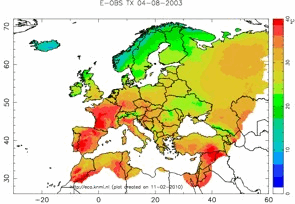
The E-OBS gridded product has been developed as part of the EU-funded project ENSEMBLES. Daily fields (+ stdev) are available at a 0.25 deg and 0.50 deg resolution from 1950 to present (updated each month). A two-step interpolation method has been used (Haylock et al., J. Geophys. Res., 2008) and the product matching the common regional climate model (RCM) grids used in Europe so that E-OBS is ideally suited for RCM evaluation. |
UK Met Office Hadley Centre Observational Datasets
Ocean Observations Panel for Climate (OOPC) global ocean observing system for climate
Data available from the UEA Climatic Research Unit